If you're working in a geodatabase, many of these will be automatically calculated and updated as features are edited, however these must be re-calculated using the Field Calculator when working with shapefiles. Here's how:
- Open a layer's attribute table
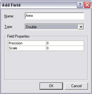
- From the Options menu at the bottom of the attribute table window choose Add Field... if some kind of area/length/etc. field does not already exist.
- Name the new field and choose Double for its type.
Again, if the layer is in a geodatabase, the SHAPE_AREA and SHAPE_LENGTH fields will be available and updated. These fields will be present in a shapefile format if they were exported from a geodatabase coverage, but you will need to re-calculate the values. Don't bother adding a new field if this is the case - just update the existing fields using the following steps
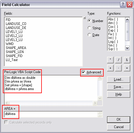
- Right click on the appropriate field (of type Double) and choose Field Calculator
- Check the Advanced option box
- Use the following code snippets to calculate the appropriate type of geometric information for each feature. I'll calculate polygon Area for this example, however I can also calculate perimeter or centroids, etc.
Paste the code (see below) in the Pre-Logic VBA Script Code box, and type the object (the variable that is created in the first line: in this case it's dblArea) in bottom most text box. Click OK when finished
- That's it!
Area
Dim dblArea as Double
Dim pArea as IArea
Set pArea = [shape]
dblArea = pArea.area
Perimeter
Dim dblPerimeter as Double
Dim pCurve as ICurve
Set pCurve = [shape]
dblPerimeter = pCurve.Length
Length
Dim dblLength as Double
Dim pCurve as ICurve
Set pCurve = [shape]
dblLength = pCurve.Length
X-coordinate of a point
Dim dblX As Double
Dim pPoint As IPoint
Set pPoint = [Shape]
dblX = pPoint.X
Y-coordinate of a point
Dim dblY As Double
Dim pPoint As IPoint
Set pPoint = [Shape]
dblY = pPoint.Y
X-coordinate of a polygon centroid
Dim dblX As Double
Dim pArea As IArea
Set pArea = [Shape]
dblX = pArea.Centroid.X
Y-coordinate of a polygon centroid
Dim dblY As Double
Dim pArea As IArea
Set pArea = [Shape]
dblY = pArea.Centroid.Y
Read more in these selected ESRI's articles:
- Making Field Calculations
- The Field Calculator Unleashed

No comments:
Post a Comment