Attribution Assistant icon
Attribution Assistant interface
This (free) application is a plugin for ArcMap 9.x that allows a user to rapidly attribute GIS data. Simply launch the tool from a button
 to quickly apply the attribution. It's as simple as that.
Features:
Use the Add
 and Remove
  buttons to manage up to 16 attribution values.
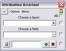
Use the check boxes to "disable" a specific field or restrict access to altering the current properties - this prevents the manipulation of information. The topmost check box enables or disables all other check boxes at once (see graphic below). Click the button in the top left corner to expand a few extra features (see below).

A layer and field are set with four attribution values
Use the Mirror tool to flip the interface for easier access to a particular control (see below). For instance if you would rather have the Attribution Assistant sit on the left side of the screen, a user can flip the interface so the mouse does not have to travel as far to click the Calculate button.

The interface is reversed with the Mirror tool
Minimize the Attribution Assistant application with the Minimize button. When you launch the tool again from the main icon on the ArcMap interface  all settings will be preserved.
Use the Import button to automatically populate the attribution boxes with (up to 16) unique values that exist in the dataset in decreasing order.
Uses:
- Basic attribution - select features on-the-fly with the Select Features Tool
 and click the calculate button on the Attribution Assistant to apply the custom value to each of the selected features. Add a blank text box that can be used to clear an existing value.
 - In an editing session - use the Attribution Assistant in an editing session to quickly attribute data as it is being digitized. Rather than clicking inside the Attributes dialog (launched from the Editor toolbar
 ) or clicking inside a cell in the Attribute Table and typing a (or pasting a copied) value for each new feature, one can simply close the polygon, click a single button to apply attribution, and continue.
Click on any label to bring up a small explanation for each feature in the application. Look for the Help pointer as you hover over a label

Installation:
View the installation instructions for this tool in the article titled, "Install Non-Packaged 3rd Party GIS Plugins"
Refer to a previous article on GIS Desktop Customization to learn about manipulating buttons/tools and toolbars on your GIS interface.

No comments:
Post a Comment